
Mineral Exploration GIS & Data Services
GIS, data compilation, mapping, and exploration data support for mineral exploration teams working with historical records, field data, assays, drill information, geochemical results, geophysical datasets, conductor interpretation, target review, and project reporting.
Experience supporting Canadian and international exploration projects across the Yukon, Quebec, Morocco, Yemen, Brazil, and Guyana as a GIS/Mapping/Data Specialist.
What This Service Helps With.
Exploration teams often work with scattered data from historical reports, field programs, geochemical sampling, drilling, geology maps, claims, permits, spreadsheets, PDFs, CAD files, and GIS layers.
OrbitalIQ helps organize that information into clean, usable spatial data so exploration teams can map targets, review results, plan fieldwork, support reporting, and make better technical decisions.
This is useful when your team needs to:
Compile historical exploration data into a usable GIS structure
Clean and organize sample, assay, collar, geology, or field datasets
Create maps for field planning, reporting, assessment work, or investor communication
Visualize geochemical results, anomalies, drill locations, claims, and access routes
Prepare spatial data packages for consultants, geologists, or project teams
Reduce manual map production and repeated data cleanup
Typical Deliverables & Support Packages
Historical Exploration Compilation Package
Georeferenced historical maps, digitized legacy features, cleaned sample and drill datasets, claim/access layers, source-data notes, organized GIS workspaces, and map outputs for review.Geochemical & Assay Mapping Package
Cleaned assay/sample tables, standardized fields and units, anomaly maps, multi-element comparison maps, classified value ranges, QA/QC notes, and report-ready figures.Geophysics & Conductor Integration Package
GIS-ready conductor picks, survey grids, magnetic/IP/EM outputs, interpreted trends, anomaly layers, target areas, and integrated map views with geology, geochemistry, claims, access, drilling, and field observations.2D / 3D Visualization & Leapfrog Support Package
2D plan maps, long sections, cross sections, 3D-ready GIS layers, DEM/terrain surfaces, drillhole and sample inputs, geology contacts, interpreted trends, and organized spatial datasets prepared for use in Leapfrog, ArcGIS Pro, QGIS, or technical review workflows.Drill Program GIS Package
Collar maps, planned versus completed hole maps, pad/access maps, target maps, drill-section inputs, downhole survey checks, assay interval preparation, and post-program GIS deliverables.Field Season GIS Setup Package
Mobile-ready GIS layers, Avenza/georeferenced PDFs, access maps, sampling grids, field forms, base maps, imagery packages, and organized data structures for field crews.Assessment & Technical Report Mapping Package
Clean report-ready maps, figures, georeferenced PDFs, data exports, source-data organization, spatial QA/QC notes, and supporting GIS packages for geologists, consultants, and Qualified Person review.
Core Support Areas
-
OrbitalIQ can help organize historical exploration records into structured GIS layers, including maps, sample locations, drill data, claim boundaries, access routes, geology, geophysics, field observations, and project reference data.
This is useful when legacy project information is spread across PDFs, spreadsheets, scanned maps, old reports, shapefiles, KMZ files, CAD drawings, or inconsistent folder structures.
-
Support for cleaning, organizing, and mapping geochemical and assay datasets so results can be reviewed spatially. This can include standardizing fields, checking coordinates, preparing sample layers, symbolizing values, and creating maps that highlight trends, anomalies, or priority areas.
Typical work can include rock, soil, stream sediment, trench, drill assay, and multi-element datasets.
-
Support for organizing, reviewing, and integrating geophysical datasets within GIS, including electromagnetic conductor picks, magnetic data, gravity data, IP/resistivity outputs, survey grids, interpreted trends, anomaly layers, and target areas.
This helps exploration teams review conductors and anomalies alongside geology, geochemistry, structures, drilling, terrain, access, claims, and field observations so potential targets can be assessed in proper spatial context.
-
Support for combining geology, structures, geochemistry, geophysical conductors, historical workings, alteration, drilling, claims, access, terrain, and field observations into practical GIS layers that help exploration teams compare targets, identify data gaps, prioritize follow-up areas, and prepare maps for technical review, field planning, or drill planning.
-
Support for preparing 2D and 3D exploration datasets for technical review, interpretation, and reporting. This can include plan maps, long sections, cross sections, terrain surfaces, drillhole inputs, sample locations, geology contacts, interpreted structures, geochemical anomalies, geophysical conductors, and target layers organized for use in Leapfrog, ArcGIS Pro, QGIS, or related review workflows.
-
Production of clean exploration maps for technical review, reports, presentations, assessment filings, and project communication. Maps can include claims, geology, samples, assays, drill holes, access, terrain, imagery, water features, infrastructure, land status, and other project context.
The goal is to make complex exploration information easier to review and communicate.
-
Setup of field-ready GIS layers, mobile maps, forms, and data collection workflows for exploration programs. This can include sample collection, mapping notes, traverses, inspection points, access observations, photos, and field verification records.
Workflows can be designed for ArcGIS Field Maps, Survey123, offline use, and later QA/QC.
-
Support for visualizing exploration information in 2D maps, sections, long sections, terrain views, dashboards, or 3D-style project views. This can help teams understand spatial patterns across samples, geology, terrain, drilling, and target areas.
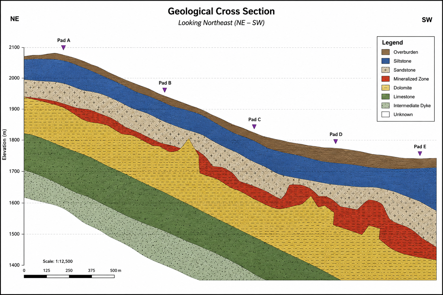
Demo geological cross-section showing interpreted lithology, mineralized zones, pad locations, elevation reference, and section orientation for exploration review. Conceptual example using demo data.
Example Use Cases
Historical Exploration Compilation
Organizing historical reports, maps, sample data, drill information, and project layers into a clean GIS workspace so the team can quickly understand what work has been completed and where gaps remain.
Geochemical Target Review
Mapping assay or geochemical results by element, threshold, anomaly class, or sample type to help identify spatial trends and priority areas for follow-up.
Drill Program Planning
Preparing maps and spatial layers showing proposed drill holes, access routes, claim boundaries, terrain, water features, previous results, and project constraints.
Assessment & Technical Reporting
Creating clean GIS figures, map layouts, and spatial data outputs that support assessment reports, technical memos, presentations, or internal project updates.
Field Program Support
Building mobile GIS workflows for sample collection, field observations, access notes, photos, and offline use during exploration field programs.
Whether you need a one-time map package, historical data cleanup, geochemical review, conductor integration, drill program support, or a full exploration GIS workspace, OrbitalIQ can help turn scattered project information into organized, usable spatial deliverables.
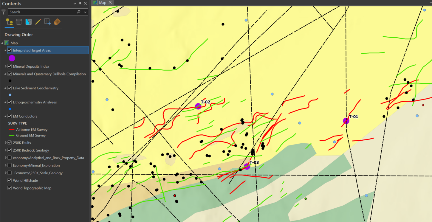
Demo exploration GIS workspace using public geoscience datasets, showing EM conductors, bedrock geology, faults, geochemical/drillhole context, and interpreted target areas for exploration review and planning.